When a renovation, remodel, or redevelopment project begins, everything depends on having accurate existing conditions. Yet too many projects still rely on outdated drawings, incomplete documentation, or manual measurements that no longer reflect what actually exists on site. The result is often delays, change orders, and avoidable rework.
This is why point clouds have become the foundation of modern As-Built documentation. By capturing existing conditions directly from the built environment, point-cloud-based As-Builts provide a precise, reliable starting point for design, coordination, and construction.
In this guide, we explain what point clouds are, how they are created, why they matter for renovation and retrofit projects, and how Precision Property Measurements uses them during the As-Built survey process to deliver dependable, design-ready As-Built drawings and models.
What Is a Point Cloud?

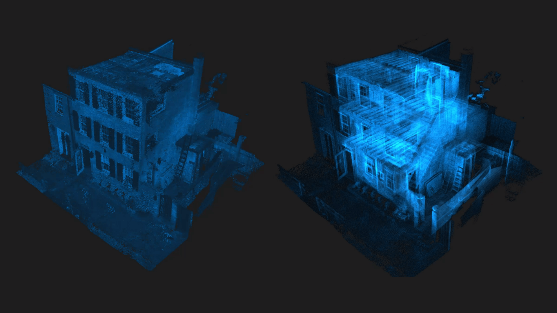
A point cloud is a dense collection of millions, and often billions, of three-dimensional data points defined by X, Y, and Z coordinates. Each point represents an exact location in physical space. When viewed together, these points form a highly accurate digital representation of a real-world environment.
Compared to manual field measurements, point clouds provide significantly higher accuracy, greater completeness, and improved reliability, particularly in complex or irregular spaces. For this reason, point clouds now serve as the baseline for professional As-Built documentation.
How Point Clouds Are Created
Creating a reliable point cloud requires professional-grade equipment, experienced operators, and proper processing workflows. At PPM, we select capture methods based on the project’s scope, geometry, and accuracy requirements.
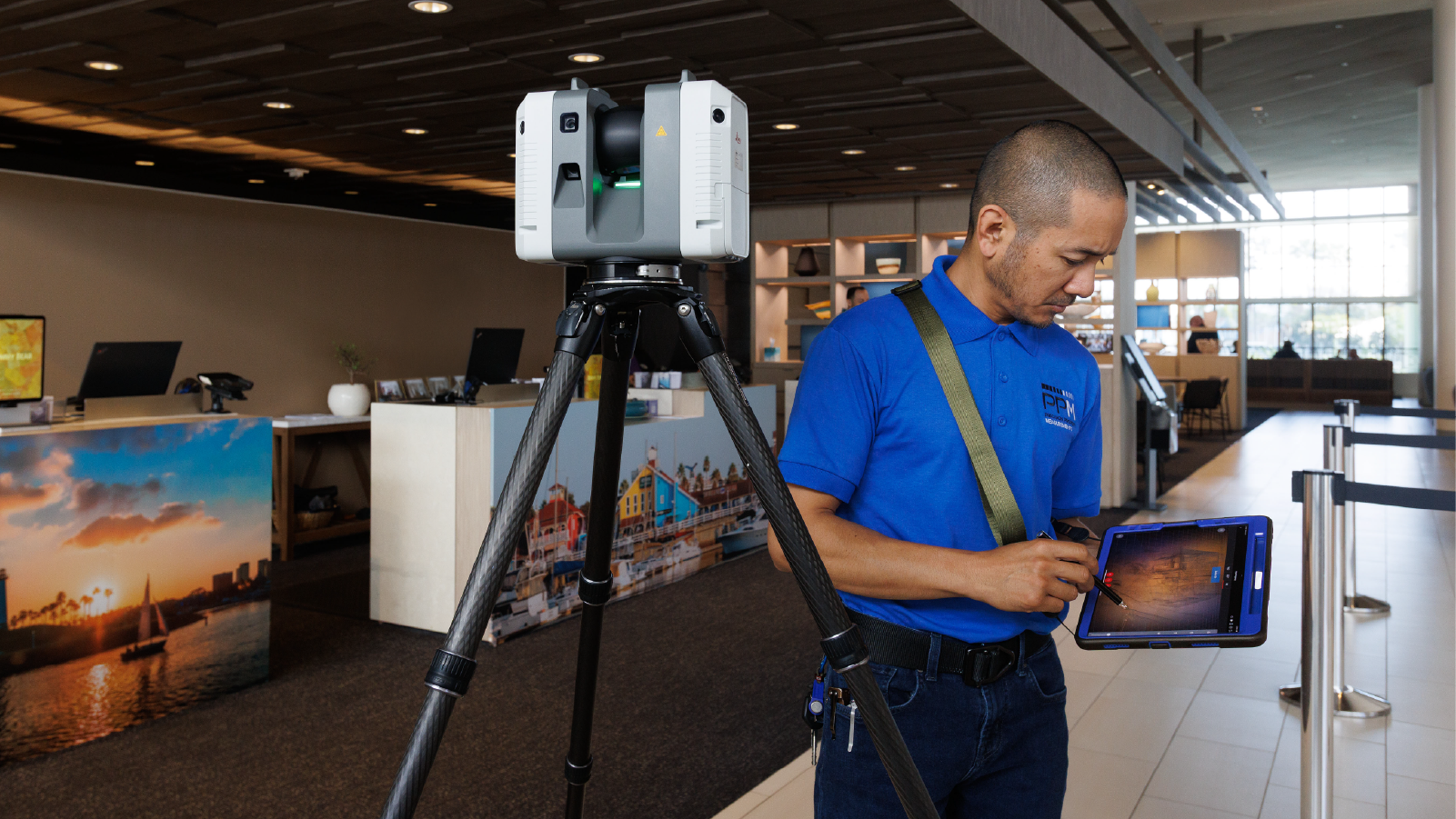
LiDAR Laser Scanning
LiDAR laser scanning is our primary method for capturing existing conditions. The technology uses laser pulses to measure distances with high speed and precision, making it well-suited for:
- Interior spaces such as offices, retail environments, and residential units
- Projects with complex geometry or structural conditions
- Capturing architectural elements and exposed MEP systems
Because LiDAR generates millions of data points rapidly, it minimizes the risk of missed dimensions and reduces the need for repeated site visits.
Photogrammetry
For large exterior areas, façades, or sites where scanning access is limited, photogrammetry may be used as a supplemental method. This process reconstructs geometry from overlapping photographs. In some cases, combining LiDAR and photogrammetry provides the most complete documentation, especially for projects with mixed interior and exterior conditions.
Regardless of the method, the quality of the final point cloud depends on proper execution, registration, and validation. Technology alone is not enough.
What Information a Point Cloud Captures
Point clouds document far more than basic room dimensions. They capture all visible conditions within a space, including:
- Walls, floors, and ceilings
- Doors and windows
- Structural framing, columns, and beams
- Visible MEP systems such as ductwork and piping
- Elevations, slopes, clearances, and spatial relationships
This level of detail is essential for producing As-Built documentation that accurately reflects existing conditions and reduces the risk of design conflicts during renovation.
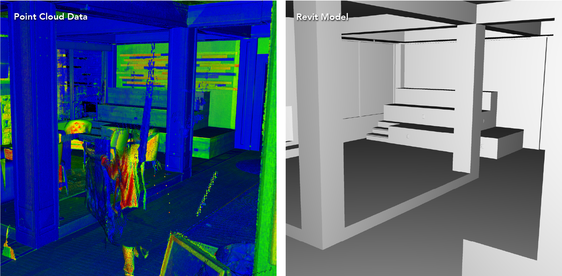
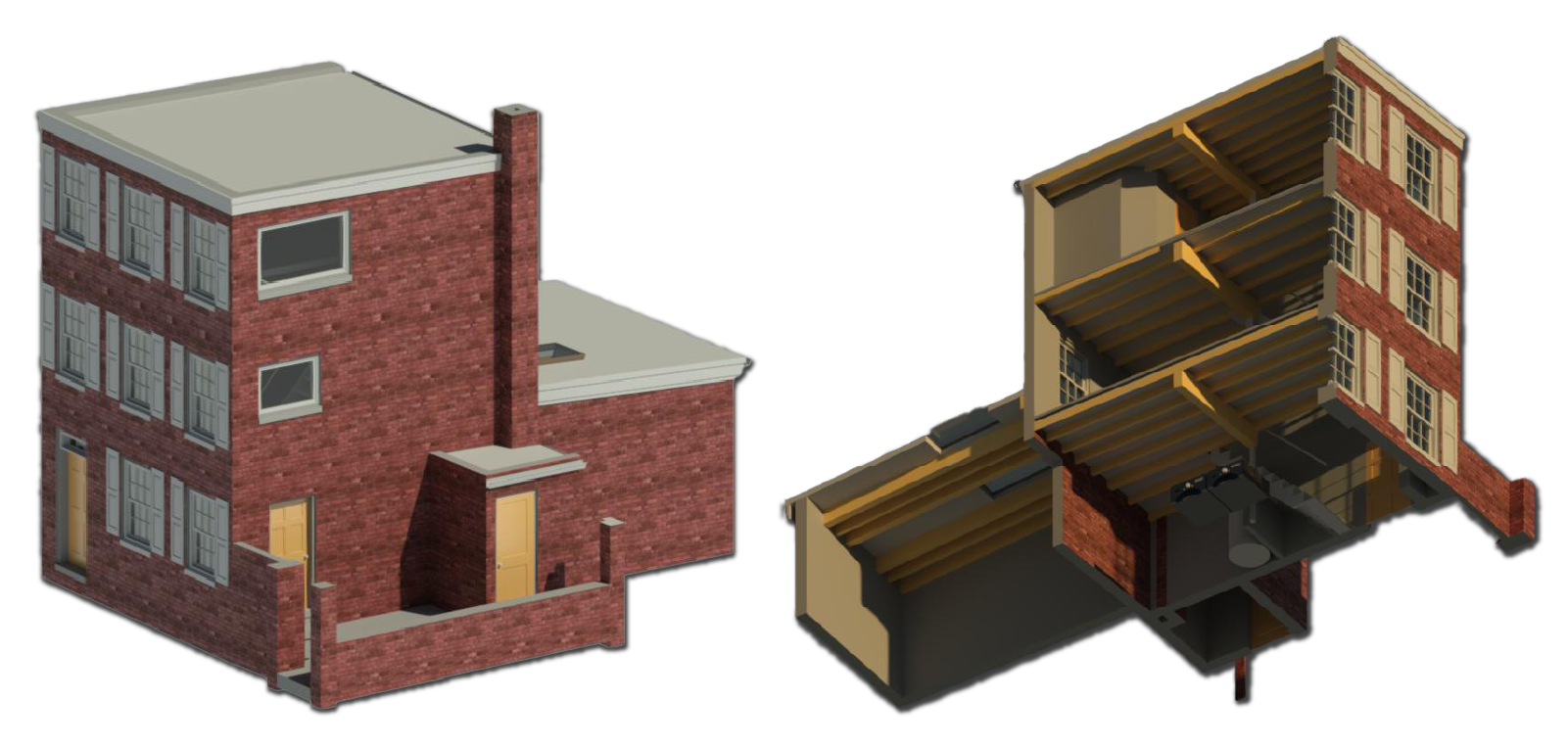
From Point Cloud to As-Built Drawings and Models

At PPM, point clouds serve as the foundation for all downstream documentation. A typical workflow includes:
- Reality Capture: On-site LiDAR scanning or hybrid capture
- Registration and Processing: Aligning scan data into a unified, accurate point cloud
- Drafting and Modeling: Using the point cloud as the baseline to produce:
- 2D floor plans
- Elevations and sections
- 3D BIM models in Revit or Archicad
Because this data is captured directly from the built environment, scan-based As-Builts consistently outperform hand-measured drawings or legacy plans, particularly for renovation and adaptive reuse projects.
Why Point Cloud–Based As-Builts Matter
Starting with scan-based As-Builts provides tangible project advantages:
- Accuracy and Confidence: Dimensions reflect existing conditions, not assumptions
- Fewer Site Revisits: Comprehensive scans reduce the need for return visits
Lower Risk: Fewer clashes and unforeseen conditions during design and construction - Faster Coordination: Teams work from a single, reliable source of truth
- Long-Term Value: Point clouds create a lasting record for future renovations or facility planning
For projects where precision matters, point clouds reduce uncertainty and support better decision-making from the start.
Common Questions About Point Clouds
How accurate are point clouds?
When properly captured and processed, modern LiDAR scanning routinely achieves sub-inch accuracy.
How long does scanning take?
Scan duration depends on project size and complexity but is typically far more efficient than manual measurement. For example, a 7,000-square-foot residence can be scanned in less than two hours and a 100,000-square-foot industrial facility can be scanned in one business day.
Can point clouds capture MEP and ceiling conditions?
Yes. Any visible systems are captured, and LiDAR scanners can also be used above ceiling to document MEP, structure, and other concealed conditions when access is available.
Are point clouds only for large commercial projects?
No. While especially valuable for large or complex sites, scan-based As-Builts are beneficial for projects of all sizes.
What deliverables are provided?
When requested, point cloud files can be provided in RCP, RCS, and E57 formats compatible with AutoCAD, Revit, Archicad, and other design software. These files allow teams to use the raw scan data as a precise reference for drafting, modeling, and future work. The most common deliverables we provide are 2D CAD drawings and 3D BIM models created from this scan data.
How Precision Property Measurements Uses Point Clouds

At PPM, point clouds are not an end product. They are a tool used to create clear, usable, project-ready documentation.
We combine professional LiDAR scanning with experienced drafting and modeling teams to deliver As-Builts that support design, permitting, coordination, and construction. Typical deliverables include:
- AutoCAD As-Built drawings
- Revit, Archicad, and SketchUp BIM models
- Still images and 360° photos
Our focus is on producing documentation that teams can rely on, not just data that looks impressive.
When Point Cloud-Based As-Builts Are the Right Choice
Scan-based As-Builts are particularly valuable when:
- Planning major renovations or tenant improvements
- Existing drawings are outdated or unavailable
- Projects involve adaptive reuse or historic structures
- Coordinating MEP systems is critical
- Managing multi-site documentation programs
In these situations, accurate existing conditions significantly reduce risk and improve project outcomes.
Starting Projects with Confidence
Point clouds represent the current standard for capturing existing conditions. By starting with precise, reality-based data, project teams reduce uncertainty, streamline coordination, and create a stronger foundation for design and construction.
When accuracy matters, Precision Property Measurements delivers dependable As-Built documentation that teams can trust.